|
三個年代
對地質學家來說,台灣東部花東縱谷及海岸山脈,不只僅是一個台灣的景點而已,它更具有「板塊構造邊界」的意涵,所以對它有著更特殊的情感。在地質上,縱谷稱之為板塊縫合帶;而海岸山脈則屬於菲律賓海板塊上的島弧系統,它碰撞上歐亞大陸;綠島、蘭嶼、及更南邊屬於菲律賓的巴丹群島,都可說是海岸山脈的向南延伸,未來將接續碰撞上歐亞大陸。安朔葉教授在台灣的第一個研究題材就是選擇這個板塊碰撞的特別區域,似乎不是個意外。 To geologists, the Longitudinal Valley and the Coastal Range mean more than simply scenic spots: they are manifestations of plate tectonics, for which geologists harbor unique feelings. In the ongoing collision of the Philippine Sea plate with Eurasia, the Longitudinal Valley represents the plate suture, and the Coastal Range belongs to the Luzon arc of the Philippine Sea plate. Angelier's 30-year odyssey to Taiwan, not surprisingly, began in such areas of the plate boundary. 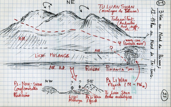
遠眺都鑾山(1981作)都鑾山是海岸山脈的最高峰,海拔約1200公尺。這是安朔葉教授來台灣的第一張場景式的野外素描,時年34歲,拿到法國國家博士學位不久,也剛被巴黎大學挖角、禮聘教授。粗獷中蒼勁的筆觸,隨手捻來,也透露出他繪畫藝術上的天分。這張素描是從卑南山上東眺海岸山脈(站在歐亞大陸板塊邊上,觀察菲律賓海板塊),圖中除了背景的都鑾山,還描繪了山前受板塊強烈擠壓,造成彎曲褶皺的岩石地層。 View to Tuluanshan (1981)Tuluanshan, with an altitude of about 1200 m, is the highest mountain in the Coastal Range. This is one of Jacques Angelier's first field sketches in Taiwan, where he arrived in 1981, not too long after receiving his "these d'etat" (National PhD Thesis) at the Univ. Pierre et Marie Curie in Paris, France. He was 34 years old then. This quick sketch shows how artistically talented he was in describing nature and rocks by drawing. 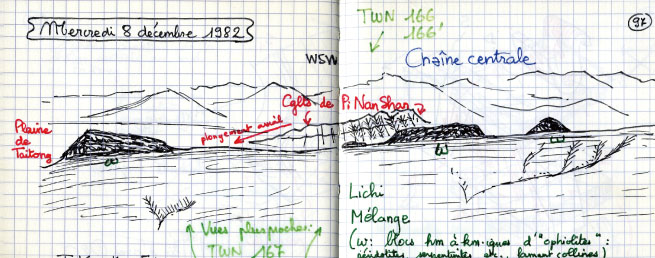 
兩山間夾擊的卑南山(1982作)卑南山在台東縣,是位於中央山脈及海岸山脈兩山間縱谷裡的一座小山,長約八公里、寬三公里。這個小山正位於歐亞大陸和菲律賓海板塊邊界,擠壓作用讓原本平坦的淺海及河流堆積層,抬升成山。安朔葉教授1982年二次造訪花東縱谷,這次站在菲律賓海板塊這一側的海岸山脈上,往西看縫合帶上的卑南山及歐亞大陸的中央山脈。細心的話,可以看到台灣地質上赫赫有名的「利吉層」中的外來岩塊(黑色小丘),也出現在地質學家的地質場景素描中。 View towards Peinanshan (1982)Peinanshan, north of Taitung City, is approximately 8 km long and 3 km wide. It lies within the Longitudinal Valley, between the Central Range and the Coastal Range. Situated right at the boundary between the converging Eurasian plate (Central Range) and the Philippine Sea plate (Coastal Range), the originally flat shallow marine and fluvial deposits became folded and were uplifted to form Peinanshan, a series of hundred-meter peaks. The second time Angelier visited the area, he stood on the Coastal Range looking west towards Peinanshan and the Central Range. Careful examination also reveals giant exotic blocks (black mounts) in the Lichi mélange, a feature casually included in this sketch drawing by a geologist. 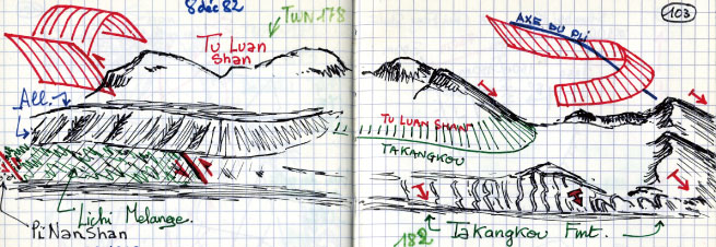
遠眺都鑾山(1982作)安朔葉教授1982年二次造訪花東縱谷,在同樣的地方(可能是鹿野),又描繪了一次都鑾山。這次,他把兩年來兩次的地質現地觀察放入到素描中:包括有都鑾山(圖中「Tu Luan Shan」)西側的逆衝斷層、北側的背斜,大港口層(圖中「TaKangKou Fmt.」)的地層傾向及褶皺,及利吉層(圖中「Lichi Melange」)兩側的逆衝斷層,及上方覆蓋的高位階地(圖中「All.」)等。 View to Tuluanshan (1982)Angelier made his second visit in 1982 to the Longitudinal Valley and the Coastal Range near Taitung. At the same location (possibly Luyeh), he made a similar sketch of Tuluanshan, but this time, he incorporated a variety of geological observations he gathered from the past two years' work in the area: a thrust fault in western Tuluanshan, an anticline within Tuluanshan, dipping direction and folding of the Takangkou Formation, thrust fault in each side of the Lichi mélange, and an overlying alluvial terrace at a higher level. 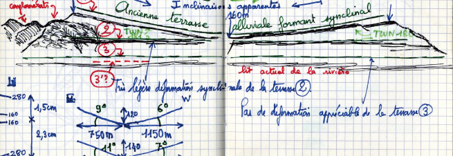 
卑南山北側傾斜階地(1982作)這是從鹿野(或龍田)往南看卑南山,也是這幾年在鹿野高台上很風行的熱氣球、拖曳傘飛行場地可以看到的景觀。安朔葉教授表達了在這個看似無奇的風景中,地質學家看到了會說話的地質地貌。1、2、3分別代表從過去到現在形成的鹿野溪河階。老的河階(1、2)隨著卑南山的持續抬升褶皺(向斜),造成老的河階在高位、老的河階更傾斜的地形。 Tilted Terraces in Peinanshan (1982)This is a view from Luyeh, looking south across Luyeh river toward Peinanshan. Three levels of terraces were delineated by Angelier, who apparently intended to illustrate the continuously growing synclinal folding of Peinanshan, and to reveal by different levels of terraces in which the older ones rest higher, with higher degrees of tilt. 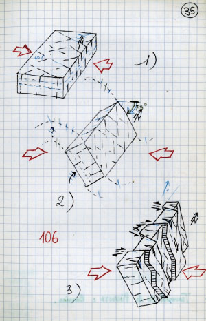
岩石斷裂演化圖速寫(1981作)構造地質學家會嘗試把野外觀察到岩石受板塊擠壓變形及產生的斷裂,將其演化過程及與地殼擠壓應力的關聯重建起來。34歲、年輕的安朔葉教授就有這方面的洞悉能力及卓越的空間繪圖概念,在野外工作中,能及時把野外的觀察,透過巧手將腦中的概念精準的畫下來。這是他觀察紀錄分析卑南山的東側地層,不但被褶皺成近垂直的位態,而且伴隨著一組共軛的斷裂(3)。這些地層原本沈積時的位態應是接近水平的(1),推斷經過水平擠壓造成共軛節理(1),爾後受同樣擠壓造成地層彎曲褶皺(2),最後節理產生斷裂(3)。 Evolution of tilted faulted strata (1981)This sketch illustrates the evolution of tilted and faulted strata in the eastern margin of the Peinanshan conglomerates, as viewed by Angelier. At 34, the young Angelier was already in possession of such perspicacious powers. Commanding superb 3-D perspective drawing concepts, he could instantly sketch state-of-the-art block diagrams in the field following observation and analysis. 
奇美秀姑巒溪(1981作)秀姑巒溪蜿蜒地從瑞穗流入並切穿海岸山脈,至大港口入海。這也是一個熱門的泛舟路線,在河中一邊隨波泛行,一邊可以看到兩岸高聳的岩壁。安朔葉教授1981年第一次來到秀姑巒溪中途點奇美村,當時瑞港公路還是羊腸小徑,途中必須經過數個吊橋。美麗的景色讓他不禁隨手素描紀錄下來。 Hsiuguluan Chi in Chimei (1981)This is a beautiful landscape for geologist or not. The Hsiuguluan River, starting from Ruishui Town in the valley, meanders through the Coastal Range and enters the sea at Takangkou. Now a popular spot for rafting, tourists enjoy sightseeing the magnificent cliff walls on both banks. When Professor Angelier first came across the Hsiuguluan River while passing through Chimei in 1981, the Ruishui road was still a country path, with several hanging bridges to cross. Struck by the inexorable beauty, he recorded what he saw in this impromptu sketch. |

