|
三個年代
正斷層,四重溪(2001)安教授來到恆春半島從事地質研究的次數不下六、七次。在他恆春半島的野外地質素描中,出現最多的地質構造大概就屬正斷層了。這張素描的露頭位於恆春四重溪,安教授的筆觸把岩性、沈積構造、斷層特徵,很生動貼切的表現在圖上。 Normal Faults, Sichongchi(2001)Kenting now is a popular place for tourists in the Hengchun peninsula by its beautiful sand beach and tropical climate. As geologist, Angelier came to the peninsula more than six times for its richness of geology, another natural heritage of the Hengchun peninsula. The most common geological feature appeared in Angelier's field notebook in the peninsula is 'normal fault', which are likely very popular in the turbidite sequence of the rock formations here. This sketch was made at Sichong River in 2001, vividly illustrating rock's lithology, sedimentary feature, and fault characteristics. 
褶皺及斷層,恆春(2009)這是安教授2009年最後一次的台灣野外地質之旅,在恆春半島工作時所繪製的野外露頭速寫。圖中再一次表現了恆春半島上的岩石富含同沈積的正斷層,在後來的造山過程中又受到了擠壓性的逆斷層作用。 Fold and Fault, Hengchun(2009)This is a field outcrop sketch during his last visit to Hengchun peninsula (also the last field trip in Taiwan) in 2009. The sketch summarized several his focuses on the geological structures, such as faulting and folding, fault-slip analysis (prompt stereonet drawing), paleostress reconstruction, and lively hand drawing (e.g., a cute small car). 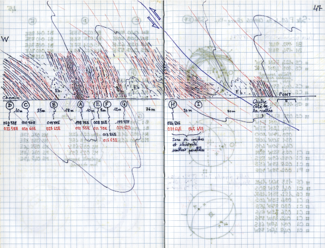
路線地質構造圖,枋山(2000)這是一張地質學家所謂的「地質路線剖面圖」。地質學家在做地質調查時,沿著勘察路線,將觀察及量測的岩石特徵描繪拼接成連續性剖面。如此可以將斷斷續續的露頭連接起來,嘗試了解山脈的整體地質構造。安教授2000年在枋山地區從事地質調查時留下的這張工作路線地質圖,是個很好的示範;舉凡地層的原始沈積層面(黑線)、變形作用中產生的劈理面(紅線)、岩層的褶皺、小斷層、大斷層、構造位態的量測及位置點、路線方位、比例尺等,都有詳細的繪製及記錄。 Outcrop road profile, Fanshan (2000)This is a typical so-called 'geological road cross section', which Angelier made during his geological field survey in the Fanshan area in 2000. It shows a good working example for young geologists (or amateurs of geology) how to make a complete description on outcrops along roadside. In the sketch, we can see original bedding of strata, slaty cleavage, local and regional folding, small and large faults, location of measurements, road orientations, scale, etc. 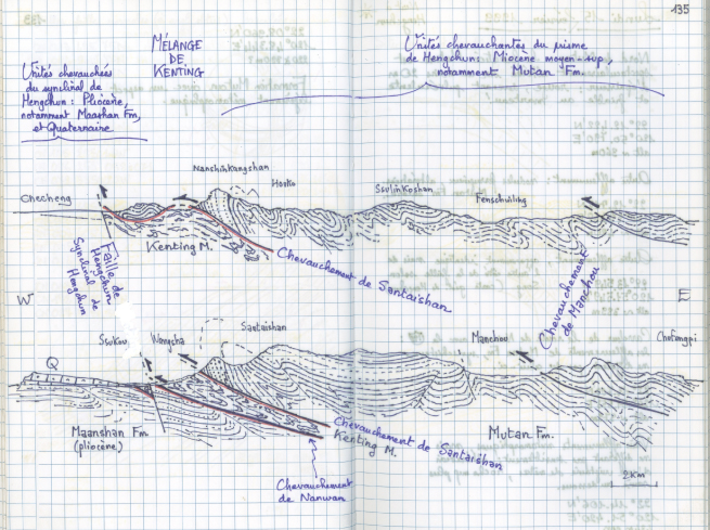
地質剖面構造圖,恆春半島(1999)安教授在這張恆春半島的地質構造剖面圖中,展現了他如何將野外觀察的現象,結合過去前人的地質資訊,用一支妙筆把複雜的地質構造畫成一張具體的圖。 Geologists have tendency to draw geological cross sections in order to illustrate their opinions about major regional structures. Angelier is no exception. Furthermore, as a structural geologist, his conceptual cross sections of the Hengchun peninsula, incorporating available information and his own field observations, show detailed structures with beautiful hand-drawing lines. |

